ESA Draws Most Accurate Ocean Maps Ever
| Marco Foronda | | Nov 27, 2014 06:53 AM EST |
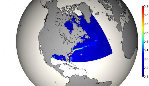
(Photo : TUM IAPG/sciencecodex.com) The image is based on the final GOCE gravity model, charts current velocities in the Gulf Stream in meters per second.
The Gravity and Ocean Circulation Explorer (GOCE) mapping satellite of the European Space Agency (ESA) has been indispensable in drawing the most accurate ocean maps yet made.
GOCE burned-up in 2013 after four years and eight months in orbit. It helped scientists make the most accurate maps of global ocean currents.
Like Us on Facebook
The satellite didn't detect and observe ocean currents directly, but its precision instruments measured the Earth's gravity. It allowed scientists to devise a computer model of what the oceans of the planet would look like if they were still.
GOCE also showed how gravity affects the ocean currents. It's difficult to isolate how currents and gravity interact in practical terms due to other forces that interact with ocean currents. This interaction sends ocean currents off from gravity-established patterns.
The gravitational pull of the Earth changes from one region of the planet to the other because of the uneven distribution of mass beneath the planet's crust and in its core.
The new precise model is important to help better understand the planet's climate. The oceans move about 30 percent of the Earth's heat.
The ocean waters' circulation has a vital role in climate regulation by transferring heat from low to high latitudes in surface waters, while currents cooled at high latitudes stream in deeper waters back toward the equator.
"GOCE has really made a breakthrough for the estimation of ocean currents," said Marie-Helene Rio from the Italian National Research Council's Institute of Atmospheric Sciences and Climate.
One of the best examples is the Gulf Stream, which brings warm surface waters northward from the Gulf of Mexico. This current makes coastal waters off Europe slightly warmer than waters at equivalent latitudes in the North Pacific.
TagsESA, Ocean map, accurate ocean map, Gravity and Ocean Circulation Explorer, GOCE, space exploration, mapping, map, ocean current, Gulf Stream
©2015 Chinatopix All rights reserved. Do not reproduce without permission
EDITOR'S PICKS
-

Did the Trump administration just announce plans for a trade war with ‘hostile’ China and Russia?
-

US Senate passes Taiwan travel bill slammed by China
-

As Yan Sihong’s family grieves, here are other Chinese students who went missing abroad. Some have never been found
-

Beijing blasts Western critics who ‘smear China’ with the term sharp power
-

China Envoy Seeks to Defuse Tensions With U.S. as a Trade War Brews
-

Singapore's Deputy PM Provides Bitcoin Vote of Confidence Amid China's Blanket Bans
-

China warns investors over risks in overseas virtual currency trading
-

Chinese government most trustworthy: survey
-

Kashima Antlers On Course For Back-To-Back Titles
MOST POPULAR
LATEST NEWS
Zhou Yongkang: China's Former Security Chief Sentenced to Life in Prison

China's former Chief of the Ministry of Public Security, Zhou Yongkang, has been given a life sentence after he was found guilty of abusing his office, bribery and deliberately ... Full Article
TRENDING STORY

China Pork Prices Expected to Stabilize As The Supplies Recover

Elephone P9000 Smartphone is now on Sale on Amazon India

There's a Big Chance Cliffhangers Won't Still Be Resolved When Grey's Anatomy Season 13 Returns

Supreme Court Ruled on Samsung vs Apple Dispute for Patent Infringement

Microsoft Surface Pro 5 Rumors and Release Date: What is the Latest?


