Integrated Software for Imagers and Spectrometers
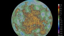
First USGS Digital Topographic Map of Mercury Shows Entire Surface
| Arthur Dominic Villasanta | | May 09, 2016 10:44 PM EDT |
Using ISIS, over 100,000 spacecraft images and photos detailing Mercury's landforms and features were combined to create the new digital map.
Advertisement
Subscribe to CHINATOPIX !
Sign up for our free weekly newsletter for the latest in-depth coverage!
EDITOR'S PICKS
-

Did the Trump administration just announce plans for a trade war with ‘hostile’ China and Russia?
-

US Senate passes Taiwan travel bill slammed by China
-

As Yan Sihong’s family grieves, here are other Chinese students who went missing abroad. Some have never been found
-

Beijing blasts Western critics who ‘smear China’ with the term sharp power
-

China Envoy Seeks to Defuse Tensions With U.S. as a Trade War Brews
-

Singapore's Deputy PM Provides Bitcoin Vote of Confidence Amid China's Blanket Bans
-

China warns investors over risks in overseas virtual currency trading
-

Chinese government most trustworthy: survey
-

Kashima Antlers On Course For Back-To-Back Titles
Advertisement
MOST POPULAR
Advertisement
LATEST NEWS
Zhou Yongkang: China's Former Security Chief Sentenced to Life in Prison

China's former Chief of the Ministry of Public Security, Zhou Yongkang, has been given a life sentence after he was found guilty of abusing his office, bribery and deliberately ... Full Article


Advertisement
TRENDING STORY

China Pork Prices Expected to Stabilize As The Supplies Recover
-
Elephone P9000 Smartphone is now on Sale on Amazon India
-
There's a Big Chance Cliffhangers Won't Still Be Resolved When Grey's Anatomy Season 13 Returns
-
Supreme Court Ruled on Samsung vs Apple Dispute for Patent Infringement
-
Microsoft Surface Pro 5 Rumors and Release Date: What is the Latest?
Advertisement