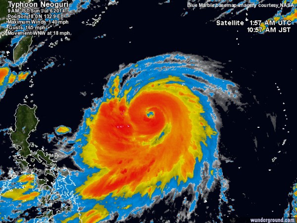
Powerful Typhoon Heading Toward Japan
| Leo J. Magpayo | | Jul 05, 2014 10:44 PM EDT |
(Photo : wunderground.com)
A potentially dangerous typhoon in the Pacific Ocean is making its way toward Okinawa and the islands of Ryukyu in Japan.
Like Us on Facebook
Typhoon Neoguri started off as a tropical depression Thursday over the islands of Guam but has now turned into a typhoon equivalent to that of a Category 4 hurricane.
Neoguri currently has maximum winds of up to 140 mph (220 kph) and wind gusts of up to 165 mph. It is tracking the direction of west-northwest at a speed of 18 mph.
It is forecast to head toward the direction of Wenzhou, China before taking a turn toward Okinawa.
By Monday morning, Neoguri is forecast to turn into a Category 5 hurricane with maximum sustained winds of more than 156 mph and is expected to make landfall Tuesday morning in the vicinity of the Ryukyu Islands.
Neoguri is expected to turn toward Kagoshima and traverse the direction toward Hiroshima in Japan and will also have an effect on Busan in South Korea. It will then exit the sea between the cities of Matsue and Tottori in the Chugoku region and will landfall again near the vicinity of Hirosaki city Aomori.
Last year's Super Typhoon Haiyan had maximum wind speed of up to 195 mph, originated from the Federated States of Micronesia, and started off as a low pressure area before turning into the strongest tropical cyclone ever observed.
Haiyan made landfall in the Philippines and Guiuan, Eastern Samar on November 8 and made its way out to the South China Sea after leaving catastrophic destruction in Samar and Leyte provinces in the Philippines.
Hurricane Arthur made landfall in North Carolina in the United States Friday and is only classified as a Category 2 storm by the National Hurricane Center in Miami, Florida with winds of 100 mph.
Tagshurricane, Hurricane Arthur, Typhoon Neoguri, Typhoon Haiyan
©2015 Chinatopix All rights reserved. Do not reproduce without permission
EDITOR'S PICKS
-

Did the Trump administration just announce plans for a trade war with ‘hostile’ China and Russia?
-

US Senate passes Taiwan travel bill slammed by China
-

As Yan Sihong’s family grieves, here are other Chinese students who went missing abroad. Some have never been found
-

Beijing blasts Western critics who ‘smear China’ with the term sharp power
-

China Envoy Seeks to Defuse Tensions With U.S. as a Trade War Brews
-

Singapore's Deputy PM Provides Bitcoin Vote of Confidence Amid China's Blanket Bans
-

China warns investors over risks in overseas virtual currency trading
-

Chinese government most trustworthy: survey
-

Kashima Antlers On Course For Back-To-Back Titles
MOST POPULAR
LATEST NEWS
Zhou Yongkang: China's Former Security Chief Sentenced to Life in Prison

China's former Chief of the Ministry of Public Security, Zhou Yongkang, has been given a life sentence after he was found guilty of abusing his office, bribery and deliberately ... Full Article
TRENDING STORY

China Pork Prices Expected to Stabilize As The Supplies Recover

Elephone P9000 Smartphone is now on Sale on Amazon India

There's a Big Chance Cliffhangers Won't Still Be Resolved When Grey's Anatomy Season 13 Returns

Supreme Court Ruled on Samsung vs Apple Dispute for Patent Infringement

Microsoft Surface Pro 5 Rumors and Release Date: What is the Latest?


