China Launches 21st Beidou Satellte to Expand Navigation System
| Charissa Echavez | | Feb 03, 2016 12:49 PM EST |

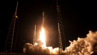
(Photo : Getty Images) In its ambitious attempt to end the US's dominance over GPS, China launched its 21st satellite on Monday to aid it transition from regional to global coverage.
China on Monday successfully launched its 21st satellite to support its global navigation and positioning network, hoping to end US' dominance on GPS.
The satellite carried by Long March 3C carrier rocket was launched from the Xichang satellite center in Sichuan province. The latest launch was China's 21st satellite in the BeiDou Navigation Satellite System, putting China a step closer to giving an alternative to the US-operated global positioning system (GPS).
Like Us on Facebook
The Beidou project, coined after the Big Dipper constellation, was officially announced in 1994, two decades after the GPS. Its first satellite was launched in 2000, and 12 years later, the People's Republic has already set up a regional network capable of providing position, timing, navigation and short messages across China and in some Asian neighboring nations.
The first 16 Beidou satellites launched only covered the country and some close locations. The 17th satellite, which is the first of the new generation series, took off in March 2015 and will aid transitioning the network from regional to global coverage.
China Daily reports that once the 21st Beidou reaches orbit, it will join its four predecessors to test inter-satellite cross-links and a new navigation signalling system, which will determine the global coverage's structure and technical standards.
According to Beidou project commander in chief, the new satellite plays a critical role as it will attempt to integrate two signal systems for regional and global navigation and switch between the two.
The Xi administration plans to widen its services to countries within the "Belt and Road" initiative in two years time and offer worldwide coverage within four years.
GPS is a space-based navigation system operated by the US Air Force. It uses a constellation of 24 or more satellite flying more than 20,000 km above the Earth's surface.
©2015 Chinatopix All rights reserved. Do not reproduce without permission


EDITOR'S PICKS
-

Did the Trump administration just announce plans for a trade war with ‘hostile’ China and Russia?
-

US Senate passes Taiwan travel bill slammed by China
-

As Yan Sihong’s family grieves, here are other Chinese students who went missing abroad. Some have never been found
-

Beijing blasts Western critics who ‘smear China’ with the term sharp power
-

China Envoy Seeks to Defuse Tensions With U.S. as a Trade War Brews
-

Singapore's Deputy PM Provides Bitcoin Vote of Confidence Amid China's Blanket Bans
-

China warns investors over risks in overseas virtual currency trading
-

Chinese government most trustworthy: survey
-

Kashima Antlers On Course For Back-To-Back Titles
MOST POPULAR
LATEST NEWS
Zhou Yongkang: China's Former Security Chief Sentenced to Life in Prison

China's former Chief of the Ministry of Public Security, Zhou Yongkang, has been given a life sentence after he was found guilty of abusing his office, bribery and deliberately ... Full Article


TRENDING STORY

China Pork Prices Expected to Stabilize As The Supplies Recover
-
Elephone P9000 Smartphone is now on Sale on Amazon India
-
There's a Big Chance Cliffhangers Won't Still Be Resolved When Grey's Anatomy Season 13 Returns
-
Supreme Court Ruled on Samsung vs Apple Dispute for Patent Infringement
-
Microsoft Surface Pro 5 Rumors and Release Date: What is the Latest?