India-US to Launch NISAR, Their First Jointly Developed Satellite
| Arthur Dominic Villasanta | | May 20, 2017 02:01 AM EDT |
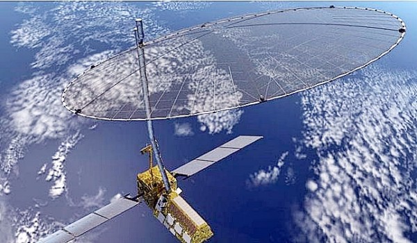
(Photo : NASA) NISAR.
The first satellite to be developed jointly by NASA and the Indian Space Research Organization (ISRO) -- the NASA-ISRO Synthetic Aperture Radar satellite (NISAR) - is the world's most expensive Earth imaging satellite.
Like Us on Facebook
NISAR will cost both national space agencies over $1.65 billion to co-develop, build and launch. The huge satellite will be launched from India in 2021 aboard India's Geo-synchronous Satellite Launch Vehicle (GSLV).
Indian political analysts see NISAR as a symbolic of the stronger ties between both India and the U.S. under Prime Minister Narendra Modi. They noted that NASA and ISRO hardly talked to each other before but this has now changed.
"NISAR is the first big collaboration between NASA and ISRO, certainly on radar but in general, as well," said Paul Rosen, a scientist working on the NISAR satellite project
He noted that NISAR is a major collaboration between India and the U.S., both in terms of the technical building of the satellite, as well as working together across the Pacific.
NISAR's payload will be an L-band (24 centimeter wavelength) polarimetric synthetic aperture radar or SAR to be produced by NASA, and an S-band (12 centimeter wavelength) polarimetric SAR to be made by ISRO.
The satellite will deploy a large mesh antenna. The 12 meter aperture mesh antenna will be supplied by Astro Aerospace, a Northrop Grumman company.
NISAR will provide an unprecedented detailed view of the Earth by using advanced radar imaging. It's designed to observe and take measurements of some of the Earth's most complex processes, including ecosystem disturbances; ice-sheet collapse and natural hazards such as earthquakes, tsunamis, volcanoes and landslides.
Data collected from NISAR will reveal information about the evolution and state of Earth's crust. It will also help scientists better understand our planet's processes and changing climate, and aid future resource and hazard management.
"We are going to be making snap shots of the Earth every week using these two radars, which will give us time lapse images of the motion of tectonic plates; of the ice sheets; of the changes in vegetation over land in agriculture and forests," said Rosen.
"So what we are doing is looking at time variability of the Earth over the life of the mission so we can understand how disasters evolve; how earthquakes occur; how volcanoes occur; how the ice sheets are changing and affecting sea level rise and how forest fires and changes in the forest cover affect the atmosphere.
"It is very relevant to what society cares about which is changes in our climate, changes in our environment and how it affects society."
Under the terms of the agreement, NASA will provide the mission's L-band SAR; a high-rate communication subsystem for science data; GPS receivers; a solid state recorder and a payload data subsystem.
ISRO will provide the satellite bus; an S-band synthetic aperture radar; the launch vehicle and associated launch services.
TagsNASA-ISRO Synthetic Aperture Radar satellite (NISAR), India, United States, Geo-synchronous Satellite Launch Vehicle (GSLV), Satellite, Paul Rosen, synthetic aperture radar, SAR, NASA, ISRO
©2015 Chinatopix All rights reserved. Do not reproduce without permission
 Indian Navy Gets US Go-ahead to Deploy EMALS and AAG on its New Supercarrier
 New Indian Armed Forces Warfighting Doctrine Emphasizes Joint Operations; Use of Space and Cyberspace
 Tavor AR; Galil Sniper Rifles to be Made in India by New Joint Venture
 Indian Air Force Must be Ready to Fight China and India Today, says its Commanding Officer
EDITOR'S PICKS
-

Did the Trump administration just announce plans for a trade war with ‘hostile’ China and Russia?
-

US Senate passes Taiwan travel bill slammed by China
-

As Yan Sihong’s family grieves, here are other Chinese students who went missing abroad. Some have never been found
-

Beijing blasts Western critics who ‘smear China’ with the term sharp power
-

China Envoy Seeks to Defuse Tensions With U.S. as a Trade War Brews
-

Singapore's Deputy PM Provides Bitcoin Vote of Confidence Amid China's Blanket Bans
-

China warns investors over risks in overseas virtual currency trading
-

Chinese government most trustworthy: survey
-

Kashima Antlers On Course For Back-To-Back Titles
MOST POPULAR
LATEST NEWS
Zhou Yongkang: China's Former Security Chief Sentenced to Life in Prison

China's former Chief of the Ministry of Public Security, Zhou Yongkang, has been given a life sentence after he was found guilty of abusing his office, bribery and deliberately ... Full Article
TRENDING STORY

China Pork Prices Expected to Stabilize As The Supplies Recover

Elephone P9000 Smartphone is now on Sale on Amazon India

There's a Big Chance Cliffhangers Won't Still Be Resolved When Grey's Anatomy Season 13 Returns

Supreme Court Ruled on Samsung vs Apple Dispute for Patent Infringement

Microsoft Surface Pro 5 Rumors and Release Date: What is the Latest?


