Pluto’s Frozen Landscape’s Stunning Map: The Most Complete till Date!
| Octhaeddeus Boral | | May 13, 2016 01:32 PM EDT |
(Photo : NASA) Pluto Map
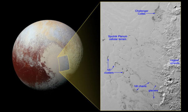
On May 2, a new composite map of Pluto was produced. The map showed most detailed and sharpest view of the dwarf planet. It showed chunks of water ice with sharp and angled corners that float amidst solid nitrogen.
According to Gizmodo, the images show water ice chunks floating amidst the bright deposits of denser, softer solid nitrogen. It also shows Pluto's icy surface which is about 2 miles (3 km) lower than the surrounding terrain. Even after eight months of New Horizons Historic Flyby of Pluto, data from the intrepid space probe continues to trickle.
Like Us on Facebook
Pluto's black and white updated global map includes all resolved images of the surface that was earlier acquired by New Horizons (July 7 to 14, 2015). Some of these new images just came during the last week of April.
In the new map, Pluto's sharpest view is available, with pixel resolutions 18 miles (30 km) on the Charon-facing side (left and right edges of the map) to 770 feet (235 meters) on the side facing New Horizons (when it made its closest approach on July 14). The planet is adorned with icy volcanoes with the activity of five moons. The non-encounter side is not shown in much detail due to greater distances at the time of image capturing.
NASA also revealed a shaded relief view of the region that surrounds the left side of Pluto's distinctive heart-shaped feature (which is informally dubbed Sputnik Planum), also known as Tombaugh Regio.
Recently, NASA also discovered the dwarf planet's moon which is much smaller than its planet. NASA is continuously working on improving the color maps and adding the photos as soon as they are received. Due to bandwidth limitations, New Horizons will take more than a year to transmit all the collected data during flyby.
TagsPluto, Space, planets, solar system, NASA
©2015 Chinatopix All rights reserved. Do not reproduce without permission
 Tesla Model S 2016 Autopilot Mode Uses Mounted Cameras, Radar, Ultrasonic Sensors [VIDEO]
 Apple Hired Full-time Nurses to Help on the Apple Watch 2; To Release its Own Data Plan
 Apple to Unveil the New MacBook Pro 2016 in Next Month's WWDC; Debut Price Set to $1500?
 Microsoft Surface Book 2 Release Delayed Until 2017; Cause of Delay Points to Intel’s Production of Kaby Lake
EDITOR'S PICKS
-

Did the Trump administration just announce plans for a trade war with ‘hostile’ China and Russia?
-

US Senate passes Taiwan travel bill slammed by China
-

As Yan Sihong’s family grieves, here are other Chinese students who went missing abroad. Some have never been found
-

Beijing blasts Western critics who ‘smear China’ with the term sharp power
-

China Envoy Seeks to Defuse Tensions With U.S. as a Trade War Brews
-

Singapore's Deputy PM Provides Bitcoin Vote of Confidence Amid China's Blanket Bans
-

China warns investors over risks in overseas virtual currency trading
-

Chinese government most trustworthy: survey
-

Kashima Antlers On Course For Back-To-Back Titles
MOST POPULAR
LATEST NEWS
Zhou Yongkang: China's Former Security Chief Sentenced to Life in Prison

China's former Chief of the Ministry of Public Security, Zhou Yongkang, has been given a life sentence after he was found guilty of abusing his office, bribery and deliberately ... Full Article
TRENDING STORY

China Pork Prices Expected to Stabilize As The Supplies Recover

Elephone P9000 Smartphone is now on Sale on Amazon India

There's a Big Chance Cliffhangers Won't Still Be Resolved When Grey's Anatomy Season 13 Returns

Supreme Court Ruled on Samsung vs Apple Dispute for Patent Infringement

Microsoft Surface Pro 5 Rumors and Release Date: What is the Latest?


